Watermark at Bearspaw, Alberta
Creative production in Watermark at Bearspaw.
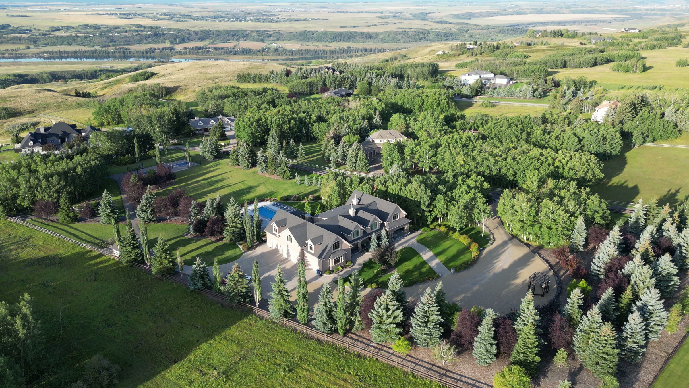
Film, photography and aerial cinematography for the homes, businesses and places that define Watermark at Bearspaw. Open upland at the eastern edge of Bearspaw country: large formal estate lots where managed lawns meet native grassland, with long sightlines in every direction and the city visible to the east from altitude.
Does Atom2Adam work in Watermark at Bearspaw?
Yes. Atom2Adam makes film, photography and aerial cinematography in Watermark at Bearspaw, Alberta — for homes, businesses and brands. For aerial work the airspace is CYYC control zone edge. An Advanced RPAS certificate covers the flight, with airspace authorisation in place before the booking is confirmed. From the Calgary studio, mobilisation is typically 25 minutes.
Watermark at Bearspaw at a glance
| Studio | Calgary, Alberta |
|---|---|
| Drive from the studio | 25 minutes |
| Airspace | CYYC control zone edge |
| Nearest aerodrome | Calgary International Airport (CYYC) |
| Aerial authorisation | Yes — filed before the date is confirmed |
| Aerial status | Flown under airspace authorisation |
| Certification | Transport Canada RPAS — Advanced Operations |
| Response | We reply within one business day |
| Airspace record derived | 2026-09-01 |
Working in Watermark at Bearspaw.
Watermark occupies open upland with an unbroken western horizon — along Watermark Boulevard and Watermark Heights nothing stands tall enough to cut the low sun, so golden hour here runs to the very end of the day instead of dying early behind terrain. Book that property for a mid-day slot and the light works against it: overhead sun flattens rooflines and stone, and the hour that justifies the build never appears in the gallery. From the ground there is no way to hold a whole estate in that late light anyway.
A golden-hour hold puts the aircraft on station for the last usable light and keeps it there, so the frames are made in the property's best hour — delivered on the turnaround agreed at booking.
Light. Golden hour swings widely across the year at this latitude — a winter shoot works the mid-afternoon, a June shoot waits for late evening. The open western exposure makes the last hour of sun dependable in every season; it is wind, not light, that usually sets the date.
Terrain. Open upland at the eastern edge of Bearspaw country: large formal estate lots where managed lawns meet native grassland, with long sightlines in every direction and the city visible to the east from altitude.
Wind. Chinook-belt ground with full western exposure. When a chinook arch builds, surface wind can rise quickly here, and the open horizon that flatters the light also gives the wind a clean run.
Airspace. Watermark at Bearspaw is about 18 km from Calgary International, near the CYYC control zone's charted boundary; a single address can fall either side of the line. The default plan treats it as controlled airspace until NAV Drone confirms otherwise, with authorisation filed before booking wherever it is required. The specific site and altitude are confirmed against NAV Drone before every flight.
On the ground. On municipal land, Rocky View County's rules apply to drone takeoff and landing; flights are flown from private property with the owner's permission as standard. About 25 minutes from the Calgary base. The airspace answer is settled at booking, and neighbouring Bearspaw, Silverhorn and Church Ranches are close enough to photograph on the same trip.
What we make for Watermark at Bearspaw.
Every subject is approached the same way — creative direction, film, photography, aerial and post-production, scoped and quoted before anything is booked.
Watermark at Bearspaw and what surrounds it.
- Film and photography in Bearspaw1 km · Mixed — CYBW control zone boundary
- Film and photography in Silverhorn2 km · CYYC control zone edge
- Film and photography in Church Ranches3 km · Class C control zone (CYBW)
- Film and photography in Cochrane15 km · Class G uncontrolled
- Film and photography in Tuscany3 km · CYYC control zone edge
How a Watermark at Bearspaw shoot runs.
- 01Brief and scope. Watermark at Bearspaw lends itself to luxury homes and acreages and estates; the shot list follows the subject. Mobilisation is stated separately from the fee.
- 02Airspace, where the brief includes aerial work. Watermark at Bearspaw sits under Calgary International Airport (CYYC), 18 km away. Authorisation is filed with NAV CANADA and the date is confirmed once it is in hand.
- 03Light and weather. Chinook-belt ground with full western exposure. When a chinook arch builds, surface wind can rise quickly here, and the open horizon that flatters the light also gives the wind a clean run. Golden hour swings widely across the year at this latitude — a winter shoot works the mid-afternoon, a June shoot waits for late evening. The open western exposure makes the last hour of sun dependable in every season; it is wind, not light, that usually sets the date.
- 04Shoot day. About 25 minutes from the Calgary studio. Launch from the subject property with the owner's permission; on municipal land, Rocky View County's rules apply to drone takeoff and landing; flights are flown from private property with the owner's permission as standard.
- 05Post-production and delivery. Edited, graded and finished for every format it will live in, delivered digitally — which is how owners of Watermark at Bearspaw property who live elsewhere can be served.
Watermark at Bearspaw questions, answered.
What airspace rules apply to a Watermark at Bearspaw shoot?
It is planned as controlled airspace. Watermark sits about 18 km from Calgary International, near the charted boundary of the CYYC control zone, and is treated as controlled until NAV Drone shows otherwise for the specific site. Where authorisation is required it is filed before the date is booked.
When should a Watermark at Bearspaw shoot be scheduled?
Against the sun, not the diary. The community's open western horizon gives it a long, dependable golden hour, and that low raking light is what separates a luxury elevation from a flat mid-day record shot. The hold is scheduled for the last usable hour and the date flexes around wind.
Why does Watermark's airspace planning differ from Church Ranches next door?
Different zones govern them. Church Ranches is planned against Springbank Airport's control zone, while Watermark sits about 18 km from Calgary International, near the charted CYYC boundary. The difference changes the paperwork, not the outcome: each site is checked against NAV Drone and any required authorisation is filed before booking.
Watermark at Bearspaw is 1 km from Bearspaw.
Every quote starts at the Calgary studio, which is why identical subjects in Watermark at Bearspaw and Bearspaw — 1 km apart — price differently.
Nearby
Airspace record derived from the published airspace geometry on . Rules change — the exact site is confirmed against NAV Drone before every flight.