Waiparous, Alberta
Creative production in Waiparous.
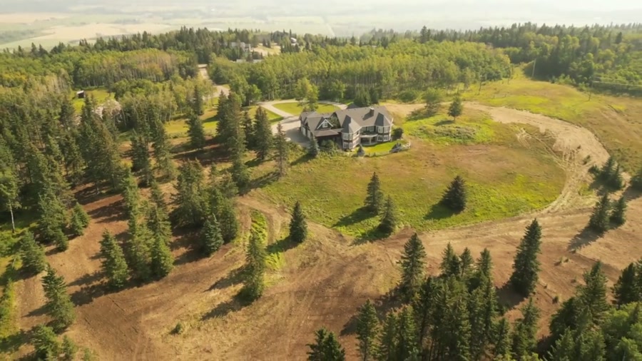
Film, photography and aerial cinematography for the homes, businesses and places that define Waiparous. Forested mountain-front country where the foothills end — cabin lots cut into pine and spruce along Waiparous Creek, the Ghost River country rising immediately west, and bare rock beginning at Old Baldy Mountain.
Does Atom2Adam work in Waiparous?
Yes. Atom2Adam makes film, photography and aerial cinematography in Waiparous, Alberta — for homes, businesses and brands. For aerial work the airspace is Class G uncontrolled. This airspace does not normally require an authorisation. Typical mobilisation from the Calgary studio is 1.1 hours.
Waiparous at a glance
| Studio | Calgary, Alberta |
|---|---|
| Drive from the studio | 1.1 hours |
| Airspace | Class G uncontrolled |
| Nearest aerodrome | Canmore municipal heliport |
| Aerial authorisation | Not normally required |
| Aerial status | Standard RPAS rules apply |
| Certification | Transport Canada RPAS — Advanced Operations |
| Response | We reply within one business day |
| Airspace record derived | 2026-09-01 |
Working in Waiparous.
Waiparous barely shows itself from the ground — the village is cabin rooflines scattered under conifer canopy along Waiparous Creek, laid out to the creek's line rather than any grid, with Old Baldy Mountain standing behind the trees. At street level the forest wins: a camera on Waiparous Village Rd sees the timber and one cabin at a time, and the setting a buyer is actually paying for — creek, forest, mountain — never lands in a single frame.
A rising reveal from the cabin's own clearing up through the canopy line assembles all three — roofline in the foreground, the creek's cut through the timber, Old Baldy behind — and the finished set is delivered on the turnaround agreed at booking.
Light. The peaks pull shadow across the village early on short days, and snow stays in the timber long after the open country east has cleared. Midsummer gives the longest usable evenings, and the conifer canopy keeps the frames green in every season.
Terrain. Forested mountain-front country where the foothills end — cabin lots cut into pine and spruce along Waiparous Creek, the Ghost River country rising immediately west, and bare rock beginning at Old Baldy Mountain.
Wind. Mountain-front air. Chinook wind descends here before it reaches the open prairie, and the Ghost and Waiparous valleys funnel it — the timber softens surface gusts inside the village while the air above the canopy runs hard.
Airspace. In uncontrolled Class G airspace about 28 km from Canmore municipal heliport, Waiparous lies outside the charted Calgary-area control zones, and no authorisation is normally required. The specific site and altitude are confirmed against NAV Drone before every flight.
On the ground. Municipal rules govern takeoff and landing on the village's roads and public land, and the Ghost River Wilderness Area is never used as a launch site; the default is staging from the client's own property with consent. About 65 minutes from the Calgary base — the far end of the same run that serves Ghost Lake and CottageClub, so bookings out here pair naturally with either. Best planned as a half-day.
What we make for Waiparous.
Every subject is approached the same way — creative direction, film, photography, aerial and post-production, scoped and quoted before anything is booked.
Waiparous and what surrounds it.
- Film and photography in Ghost Lake26 km · Class G uncontrolled
- Film and photography in CottageClub at Ghost Lake25 km · Class G uncontrolled
- Film and photography in Cremona51 km · Class G uncontrolled
- Film and photography in Morley21 km · Class G uncontrolled airspace over First Nation land
- Film and photography in Bottrel42 km · Class G uncontrolled
How a Waiparous shoot runs.
- 01Brief and scope. Waiparous lends itself to luxury homes and acreages and estates; the shot list follows the subject. Mobilisation is stated separately from the fee.
- 02Airspace, where the brief includes aerial work. Checked against NAV Drone from the address, not the postcode. Waiparous is class g uncontrolled, so authorisation is not normally required — but Canmore municipal heliport is 28 km away and its circuit is plotted regardless.
- 03Light and weather. Mountain-front air. Chinook wind descends here before it reaches the open prairie, and the Ghost and Waiparous valleys funnel it — the timber softens surface gusts inside the village while the air above the canopy runs hard. The peaks pull shadow across the village early on short days, and snow stays in the timber long after the open country east has cleared. Midsummer gives the longest usable evenings, and the conifer canopy keeps the frames green in every season.
- 04Shoot day. About 65 minutes from the Calgary studio. Launch from the subject property with the owner's permission; municipal rules govern takeoff and landing on the village's roads and public land, and the Ghost River Wilderness Area is never used as a launch site; the default is staging from the client's own property with consent.
- 05Post-production and delivery. Edited, graded and finished for every format it will live in, delivered digitally — which is how owners of Waiparous property who live elsewhere can be served.
Waiparous questions, answered.
Do you need authorisation to fly a drone at Waiparous?
No. Waiparous sits in uncontrolled Class G airspace, well outside the charted Calgary-area control zones, with the nearest aerodrome the Canmore municipal heliport about 28 km away. No airspace authorisation is normally required. The specific site and altitude are still confirmed against NAV Drone before every flight.
Can aerial photos at Waiparous include the Ghost River Wilderness Area?
As a backdrop, yes. The flight itself stays over the village and the client's property — the wilderness area is not overflown or used as a launch site — but from altitude above Waiparous the camera can hold the Ghost country and Old Baldy Mountain as the horizon behind a cabin.
Waiparous is 26 km from Ghost Lake.
Every quote starts at the Calgary studio, which is why identical subjects in Waiparous and Ghost Lake — 26 km apart — price differently.
Nearby
Airspace record derived from the published airspace geometry on . Rules change — the exact site is confirmed against NAV Drone before every flight.