Jumping Pound, Alberta
Creative production in Jumping Pound.
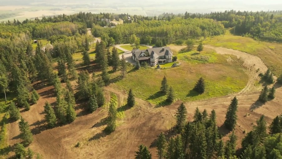
Film, photography and aerial cinematography for the homes, businesses and places that define Jumping Pound. Front-range foothill ranch country — high rolling grass broken by aspen bluffs, Jumping Pound Creek cutting through it, and managed forest rising west toward Sibbald Flat and the Powderface Trail trailhead.
Does Atom2Adam work in Jumping Pound?
Yes. Atom2Adam makes film, photography and aerial cinematography in Jumping Pound, Alberta — for homes, businesses and brands. For aerial work the airspace is Class G uncontrolled. No airspace authorisation is normally required. Typical mobilisation from the Calgary studio is 50 minutes.
Jumping Pound at a glance
| Studio | Calgary, Alberta |
|---|---|
| Drive from the studio | 50 minutes |
| Airspace | Class G uncontrolled |
| Nearest aerodrome | Springbank Airport (CYBW) |
| Aerial authorisation | Not normally required |
| Aerial status | Standard RPAS rules apply |
| Certification | Transport Canada RPAS — Advanced Operations |
| Response | We reply within one business day |
| Airspace record derived | 2026-09-01 |
Working in Jumping Pound.
From altitude the built form at Jumping Pound is the ranch yard: house, barn, shelterbelt and corrals gathered into one tight cluster, repeated along Jumping Pound Rd and Hwy 68 with open grazing land between neighbours. A ground camera can photograph the buildings or the land, never the relationship between them — and out here the relationship is the value: how much country a yard commands and how the creek and roads reach it.
A wide boundary-line orbit, flown high enough to hold the whole holding — yard at centre, fence lines running to the frame edges, Jumping Pound Creek where it crosses — delivered on the turnaround agreed at booking.
Light. Grass country carries colour longer than grain: the hills hold green into midsummer and cure to gold rather than stubble. Low autumn sun rakes across the ridgelines and makes the relief legible; midwinter flattens it under snow.
Terrain. Front-range foothill ranch country — high rolling grass broken by aspen bluffs, Jumping Pound Creek cutting through it, and managed forest rising west toward Sibbald Flat and the Powderface Trail trailhead.
Wind. This is the first open ground east of the front ranges, and chinook wind crosses it at full strength — gusty, dry, and often strongest in exactly the clear weather that looks best from the air.
Airspace. Jumping Pound lies outside the charted Calgary-area control zones in uncontrolled Class G airspace, about 30 km from Springbank Airport (CYBW). No airspace authorisation is normally required. The specific site and altitude are confirmed against NAV Drone before every flight.
On the ground. Rocky View County's rules govern takeoff from public land here, and the Jumping Pound Demonstration Forest is not treated as a launch site; the working default is staging from the client's own property with consent. Roughly 50 minutes from the Calgary base. An easy half-day, and Springbank or Bragg Creek bookings can share the same run west.
What we make for Jumping Pound.
Every subject is approached the same way — creative direction, film, photography, aerial and post-production, scoped and quoted before anything is booked.
Jumping Pound and what surrounds it.
- Film and photography in Bottrel46 km · Class G uncontrolled
- Film and photography in Springbank29 km · Class C control zone (CYBW)
- Film and photography in Bragg Creek18 km · Class G uncontrolled
- Film and photography in Cochrane28 km · Class G uncontrolled
- Film and photography in Ghost Lake21 km · Class G uncontrolled
How a Jumping Pound shoot runs.
- 01Brief and scope. Jumping Pound lends itself to acreages and estates and farms and ranch land; the shot list follows the subject. Mobilisation is stated separately from the fee.
- 02Airspace, where the brief includes aerial work. Checked against NAV Drone from the address, not the postcode. Jumping Pound is class g uncontrolled, so authorisation is not normally required — but Springbank Airport (CYBW) is 30 km away and its circuit is plotted regardless.
- 03Light and weather. This is the first open ground east of the front ranges, and chinook wind crosses it at full strength — gusty, dry, and often strongest in exactly the clear weather that looks best from the air. Grass country carries colour longer than grain: the hills hold green into midsummer and cure to gold rather than stubble. Low autumn sun rakes across the ridgelines and makes the relief legible; midwinter flattens it under snow.
- 04Shoot day. About 50 minutes from the Calgary studio. Launch from the subject property with the owner's permission; rocky View County's rules govern takeoff from public land here, and the Jumping Pound Demonstration Forest is not treated as a launch site; the working default is staging from the client's own property with consent.
- 05Post-production and delivery. Edited, graded and finished for every format it will live in, delivered digitally — which is how owners of Jumping Pound property who live elsewhere can be served.
Jumping Pound questions, answered.
Is Jumping Pound affected by the Springbank Airport control zone?
No — the district sits in uncontrolled Class G airspace about 30 km from Springbank Airport (CYBW), outside the charted control zone, so no airspace authorisation is normally required. Because traffic thickens toward Springbank on the corridor east, the exact site and altitude are confirmed against NAV Drone before every flight.
Can one flight show an entire ranch holding at Jumping Pound?
Usually, yes. Within the legal altitude limit, an orbit flown wide of the yard can hold the buildings, the fence lines and Jumping Pound Creek in a single frame. Larger holdings are covered as a short series of overlapping frames along the boundary rather than one impossible wide shot.
Jumping Pound is 46 km from Bottrel.
Every quote starts at the Calgary studio, which is why identical subjects in Jumping Pound and Bottrel — 46 km apart — price differently.
Nearby
Airspace record derived from the published airspace geometry on . Rules change — the exact site is confirmed against NAV Drone before every flight.