Bragg Creek, Alberta
Creative production in Bragg Creek.
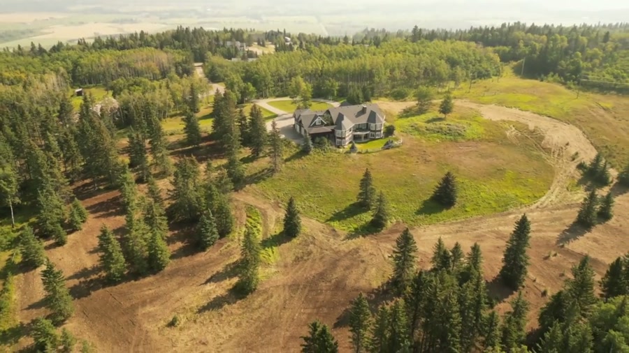
Film, photography and aerial cinematography for the homes, businesses and places that define Bragg Creek. Forested foothills on the Elbow River. Dense spruce and pine, meaningful elevation change, and the front ranges immediately west.
Does Atom2Adam work in Bragg Creek?
Yes. Atom2Adam makes film, photography and aerial cinematography in Bragg Creek, Alberta — for homes, businesses and brands. For aerial work the airspace is Class G uncontrolled. No airspace authorisation is normally required. From the Calgary studio, mobilisation is typically 45 minutes.
Bragg Creek at a glance
| Studio | Calgary, Alberta |
|---|---|
| Drive from the studio | 45 minutes |
| Airspace | Class G uncontrolled |
| Nearest aerodrome | Springbank Airport (CYBW) |
| Aerial authorisation | Not normally required |
| Aerial status | Standard RPAS rules apply |
| Certification | Transport Canada RPAS — Advanced Operations |
| Response | We reply within one business day |
| Airspace record derived | 2026-08-31 |
Working in Bragg Creek.
Bragg Creek sits where the foothills stop being rolling and start being forest, with Kananaskis Country provincial land beginning a short distance west. A shot list that drifts west can cross onto provincial park land where different rules apply, and the boundary is not marked in the sky.
The provincial boundary is plotted alongside the airspace check, so the flown area is settled before the airframe leaves the case.
Light. Autumn larch and aspen colour is the strongest window. Winter gives clean contrast between snow and dark conifer.
Terrain. Forested foothills on the Elbow River. Dense spruce and pine, meaningful elevation change, and the front ranges immediately west.
Wind. Foothills valley wind, funnelled by the river corridor and unpredictable in the lee of ridges.
Airspace. Bragg Creek sits in uncontrolled Class G airspace west of the Springbank control zone. Kananaskis Country provincial land begins nearby and carries its own restrictions. This is a corridor-level assessment; the specific address is confirmed against NAV Drone (opens in a new tab) before every flight.
On the ground. Rocky View County rules apply in the hamlet; Kananaskis Country provincial restrictions begin west and south. About 45 minutes south-west of the Calgary base on Highway 22. Day-trip scheduling; the light window closes early against the ridges.
What we make for Bragg Creek.
Every subject is approached the same way — creative direction, film, photography, aerial and post-production, scoped and quoted before anything is booked.
Bragg Creek and what surrounds it.
- Film and photography in Elbow Valley18 km · Class C control zone (CYBW) vicinity
- Film and photography in Redwood Meadows1 km · Class G uncontrolled
- Film and photography in Priddis19 km · Class G uncontrolled
- Film and photography in Springbank20 km · Class C control zone (CYBW)
- Film and photography in Cochrane28 km · Class G uncontrolled
How a Bragg Creek shoot runs.
- 01Brief and scope. Bragg Creek lends itself to acreages and estates and hospitality and tourism; the shot list follows the subject. Mobilisation is stated separately from the fee.
- 02Airspace, where the brief includes aerial work. Checked against NAV Drone from the address, not the postcode. Bragg Creek is class g uncontrolled, so authorisation is not normally required — but Springbank Airport (CYBW) is 24 km away and its circuit is plotted regardless.
- 03Light and weather. Foothills valley wind, funnelled by the river corridor and unpredictable in the lee of ridges. Autumn larch and aspen colour is the strongest window. Winter gives clean contrast between snow and dark conifer.
- 04Shoot day. About 45 minutes from the Calgary studio. Launch from the subject property with the owner's permission; rocky View County rules apply in the hamlet; Kananaskis Country provincial restrictions begin west and south.
- 05Post-production and delivery. Edited, graded and finished for every format it will live in, delivered digitally — which is how owners of Bragg Creek property who live elsewhere can be served.
Bragg Creek questions, answered.
Can you fly a drone in Bragg Creek?
Yes. The hamlet sits in uncontrolled Class G airspace west of the Springbank control zone, so no NAV CANADA authorisation is normally required. Kananaskis Country provincial land begins nearby and is plotted before the flight.
Can you fly into Kananaskis Country from Bragg Creek?
Not without checking the specific provincial restrictions that apply. Kananaskis is provincial park land with its own rules, and the boundary is invisible from the air, so it is plotted on the flight plan alongside the airspace check.
What is the best season for Bragg Creek aerial work?
Autumn, for colour contrast between aspen and conifer, or midwinter, for the clean separation between snow and dark spruce. Midsummer flattens the forest into a single green mass from altitude.
Bragg Creek is 18 km from Elbow Valley.
Mobilisation is quoted from the Calgary studio, so a shoot in Bragg Creek and one 18 km away in Elbow Valley are priced differently even when the subject is identical.
Nearby
Airspace record derived from the published airspace geometry on . Rules change — the exact site is confirmed against NAV Drone before every flight.