Water Valley, Alberta
Creative production in Water Valley.
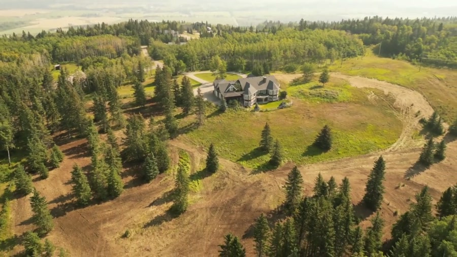
Film, photography and aerial cinematography for the homes, businesses and places that define Water Valley. Rolling, heavily treed foothill country — small clearings, pasture pockets and lake basins cut out of mixed forest, closer in character to the mountains than to the prairie east of it.
Does Atom2Adam work in Water Valley?
Yes. Atom2Adam makes film, photography and aerial cinematography in Water Valley, Alberta — for homes, businesses and brands. For aerial work the airspace is Class G uncontrolled. This airspace does not normally require an authorisation. Typical mobilisation from the Calgary studio is 1 hours.
Water Valley at a glance
| Studio | Calgary, Alberta |
|---|---|
| Drive from the studio | 1 hours |
| Airspace | Class G uncontrolled |
| Nearest aerodrome | Sundre aerodrome |
| Aerial authorisation | Not normally required |
| Aerial status | Standard RPAS rules apply |
| Certification | Transport Canada RPAS — Advanced Operations |
| Response | We reply within one business day |
| Airspace record derived | 2026-09-01 |
Working in Water Valley.
From above, Water Valley is a single cluster of rooflines strung along Highway 579 — a clearing in foothill forest that closes back in directly behind the lots. A ground camera standing in that clearing sees buildings and a treeline; it cannot show that the forest is the setting, and the setting is what a buyer out here is paying for.
A rising reveal from street height to above the canopy turns the treeline into a frame — hamlet, timber and, at the right angle, Winchell Lake in one shot, delivered on the turnaround agreed at booking.
Light. Snow sits in the timber and on shaded ground here after Calgary has cleared, and autumn turns the deciduous stands around the Water Valley Golf & Country Club gold for a short window — the strongest colour the hamlet shows all year.
Terrain. Rolling, heavily treed foothill country — small clearings, pasture pockets and lake basins cut out of mixed forest, closer in character to the mountains than to the prairie east of it.
Wind. Still the chinook belt, though the treed, rolling ground breaks up surface wind more than the open grain country to the east; above the canopy it blows unbroken.
Airspace. In uncontrolled Class G airspace about 25 km from Sundre aerodrome, Water Valley lies outside the charted Calgary-area control zones, and no authorisation is normally required. Before any flight, the exact site and altitude are checked against NAV Drone.
On the ground. Local municipal rules apply to launches from public land in the hamlet; takeoff and landing from private property with the owner's consent is the standard approach. About an hour from the Calgary base. Best booked as a half-day; Cremona and Dog Pound sit on the same run and can share the mobilisation.
What we make for Water Valley.
Every subject is approached the same way — creative direction, film, photography, aerial and post-production, scoped and quoted before anything is booked.
Water Valley and what surrounds it.
- Film and photography in Cremona10 km · Class G uncontrolled
- Film and photography in Madden29 km · Class G uncontrolled
- Film and photography in Dog Pound16 km · Class G uncontrolled
- Film and photography in Cochrane42 km · Class G uncontrolled
- Film and photography in Bragg Creek67 km · Class G uncontrolled
How a Water Valley shoot runs.
- 01Brief and scope. Water Valley lends itself to luxury homes and lakefront property; the shot list follows the subject. Mobilisation is stated separately from the fee.
- 02Airspace, where the brief includes aerial work. Checked against NAV Drone from the address, not the postcode. Water Valley is class g uncontrolled, so authorisation is not normally required — but Sundre aerodrome is 25 km away and its circuit is plotted regardless.
- 03Light and weather. Still the chinook belt, though the treed, rolling ground breaks up surface wind more than the open grain country to the east; above the canopy it blows unbroken. Snow sits in the timber and on shaded ground here after Calgary has cleared, and autumn turns the deciduous stands around the Water Valley Golf & Country Club gold for a short window — the strongest colour the hamlet shows all year.
- 04Shoot day. About 60 minutes from the Calgary studio. Launch from the subject property with the owner's permission; local municipal rules apply to launches from public land in the hamlet; takeoff and landing from private property with the owner's consent is the standard approach.
- 05Post-production and delivery. Edited, graded and finished for every format it will live in, delivered digitally — which is how owners of Water Valley property who live elsewhere can be served.
Water Valley questions, answered.
Are there flight restrictions over Water Valley?
None beyond the standard rules. Water Valley lies in uncontrolled Class G airspace, roughly 25 km from Sundre aerodrome and outside every charted Calgary-area control zone, so no airspace authorisation is normally required. The exact site is verified against NAV Drone before the flight, as it is everywhere.
What does aerial photography show at Water Valley that ground photos miss?
The forest edge. Most properties here are clearings in treed foothill country, and the value is the timber around them — something a ground camera can only hint at. From altitude, one frame holds the buildings, the surrounding stands and, on the right side of the hamlet, Winchell Lake.
Water Valley is 10 km from Cremona.
Mobilisation is quoted from the Calgary studio, so a shoot in Water Valley and one 10 km away in Cremona are priced differently even when the subject is identical.
Nearby
Airspace record derived from the published airspace geometry on . Rules change — the exact site is confirmed against NAV Drone before every flight.