Priddis, Alberta
Creative production in Priddis.
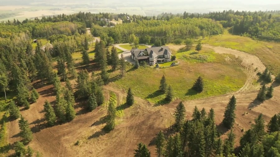
Film, photography and aerial cinematography for the homes, businesses and places that define Priddis. Genuine foothills relief — folded ridges and wooded draws, with parcels frequently running over more than one crest.
Does Atom2Adam work in Priddis?
Yes. Atom2Adam makes film, photography and aerial cinematography in Priddis, Alberta — for homes, businesses and brands. For aerial work the airspace is Class G uncontrolled. This airspace does not normally require an authorisation. Typical mobilisation from the Calgary studio is 35 minutes.
Priddis at a glance
| Studio | Calgary, Alberta |
|---|---|
| Drive from the studio | 35 minutes |
| Airspace | Class G uncontrolled |
| Nearest aerodrome | Springbank Airport (CYBW) |
| Aerial authorisation | Not normally required |
| Aerial status | Standard RPAS rules apply |
| Certification | Transport Canada RPAS — Advanced Operations |
| Response | We reply within one business day |
| Airspace record derived | 2026-08-31 |
Working in Priddis.
Priddis sits in the first real fold of the foothills, where the ground stops being prairie and starts having genuine relief. That relief hides property boundaries completely — a parcel can run over a ridge and out of sight from every point on the driveway.
An altitude pass flattens the terrain into a readable plan view while a lower orbit preserves the sense of the fold, and both go in the same delivery.
Light. Autumn colour in the draws gives the strongest separation; winter shows terrain shape most clearly under low sun.
Terrain. Genuine foothills relief — folded ridges and wooded draws, with parcels frequently running over more than one crest.
Wind. Ridge-and-draw wind behaviour, with sharp local variation over short distances.
Airspace. Priddis sits in uncontrolled Class G airspace south-west of the Springbank control zone. The northern parcels are confirmed individually. This is a corridor-level assessment; the specific address is confirmed against NAV Drone (opens in a new tab) before every flight.
On the ground. Foothills County rules apply; Kananaskis provincial land begins further west and carries separate restrictions. About 35 minutes south-west of the Calgary base on Highway 22.
What we make for Priddis.
Every subject is approached the same way — creative direction, film, photography, aerial and post-production, scoped and quoted before anything is booked.
Priddis and what surrounds it.
- Film and photography in Bragg Creek19 km · Class G uncontrolled
- Film and photography in De Winton27 km · Class G uncontrolled
- Film and photography in Okotoks30 km · Class G uncontrolled
- Film and photography in Elbow Valley15 km · Class C control zone (CYBW) vicinity
- Film and photography in Millarville16 km · Class G uncontrolled
How a Priddis shoot runs.
- 01Brief and scope. Priddis lends itself to acreages and estates and resorts and mountain property; the shot list follows the subject. Mobilisation is stated separately from the fee.
- 02Airspace, where the brief includes aerial work. Checked against NAV Drone from the address, not the postcode. Priddis is class g uncontrolled, so authorisation is not normally required — but Springbank Airport (CYBW) is 21 km away and its circuit is plotted regardless.
- 03Light and weather. Ridge-and-draw wind behaviour, with sharp local variation over short distances. Autumn colour in the draws gives the strongest separation; winter shows terrain shape most clearly under low sun.
- 04Shoot day. About 35 minutes from the Calgary studio. Launch from the subject property with the owner's permission; foothills County rules apply; Kananaskis provincial land begins further west and carries separate restrictions.
- 05Post-production and delivery. Edited, graded and finished for every format it will live in, delivered digitally — which is how owners of Priddis property who live elsewhere can be served.
Priddis questions, answered.
Can you fly a drone in Priddis?
Yes. Priddis sits in uncontrolled Class G airspace south-west of the Springbank control zone, so no authorisation is normally required. Northern parcels closest to the boundary are confirmed individually.
How does foothills terrain change an acreage shoot?
It hides the parcel. Around Priddis a property can run over a ridge and be entirely invisible from the driveway. The delivery pairs a high plan view for boundaries with a lower orbit that keeps the sense of the terrain.
Priddis is 19 km from Bragg Creek.
Mobilisation is quoted from the Calgary studio, so a shoot in Priddis and one 19 km away in Bragg Creek are priced differently even when the subject is identical.
Nearby
Airspace record derived from the published airspace geometry on . Rules change — the exact site is confirmed against NAV Drone before every flight.