Okotoks, Alberta
Creative production in Okotoks.
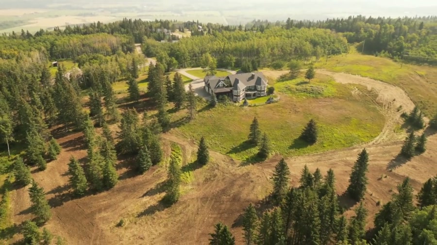
Film, photography and aerial cinematography for the homes, businesses and places that define Okotoks. A river valley cutting through foothills ranch country. The Sheep River provides the only significant relief; the rest is long, open rolling ground.
Does Atom2Adam work in Okotoks?
Yes. Atom2Adam makes film, photography and aerial cinematography in Okotoks, Alberta — for homes, businesses and brands. For aerial work the airspace is Class G uncontrolled. This airspace does not normally require an authorisation. From the Calgary studio, mobilisation is typically 35 minutes.
Okotoks at a glance
| Studio | Calgary, Alberta |
|---|---|
| Drive from the studio | 35 minutes |
| Airspace | Class G uncontrolled |
| Nearest aerodrome | Okotoks Air Park |
| Aerial authorisation | Not normally required |
| Aerial status | Standard RPAS rules apply |
| Certification | Transport Canada RPAS — Advanced Operations |
| Response | We reply within one business day |
| Airspace record derived | 2026-08-31 |
Working in Okotoks.
Okotoks sits in the Sheep River valley with an uninterrupted west-facing view to the Rockies and nothing but ranch land in between. That mountain sightline is a real part of what a property here sells on, and it only exists in a frame shot late, low and facing west.
Shoots are scheduled into the last hour of light with the approach flown from the east, so the Rockies sit behind the property rather than out of frame.
Light. The cleanest west-facing golden hour in the service area — there is nothing between Okotoks and the mountains to break the light.
Terrain. A river valley cutting through foothills ranch country. The Sheep River provides the only significant relief; the rest is long, open rolling ground.
Wind. Foothills chinook exposure. West wind arrives off the front ranges with little to slow it.
Airspace. Okotoks sits in uncontrolled Class G airspace clear of the Calgary control zone. The Okotoks Air Park creates a localised constraint that is plotted before the flight. This is a corridor-level assessment; the specific address is confirmed against NAV Drone (opens in a new tab) before every flight.
On the ground. Town of Okotoks park rules govern municipal land; river-valley pathway areas carry their own restrictions. About 35 minutes south of the Calgary base. Same-day scheduling is realistic.
What we make for Okotoks.
Every subject is approached the same way — creative direction, film, photography, aerial and post-production, scoped and quoted before anything is booked.
Okotoks and what surrounds it.
- Film and photography in High River18 km · Class G uncontrolled
- Film and photography in De Winton12 km · Class G uncontrolled
- Film and photography in Priddis30 km · Class G uncontrolled
- Film and photography in Aldersyde5 km · Class G uncontrolled, local aerodrome nearby
- Film and photography in Calgary36 km · Class C control zone (CYYC)
How an Okotoks shoot runs.
- 01Brief and scope. Okotoks lends itself to luxury homes and acreages and estates; the shot list follows the subject. Mobilisation is stated separately from the fee.
- 02Airspace, where the brief includes aerial work. Checked against NAV Drone from the address, not the postcode. Okotoks is class g uncontrolled, so authorisation is not normally required — but Okotoks Air Park is 6 km away and its circuit is plotted regardless.
- 03Light and weather. Foothills chinook exposure. West wind arrives off the front ranges with little to slow it. The cleanest west-facing golden hour in the service area — there is nothing between Okotoks and the mountains to break the light.
- 04Shoot day. About 35 minutes from the Calgary studio. Launch from the subject property with the owner's permission; town of Okotoks park rules govern municipal land; river-valley pathway areas carry their own restrictions.
- 05Post-production and delivery. Edited, graded and finished for every format it will live in, delivered digitally — which is how owners of Okotoks property who live elsewhere can be served.
Okotoks questions, answered.
Do you need airspace authorisation to fly a drone in Okotoks?
Generally no. Okotoks sits in uncontrolled Class G airspace clear of the Calgary control zone. The Okotoks Air Park creates a localised constraint nearby, so the flight plan is plotted against the circuit before the shoot.
Does an Okotoks property really photograph the Rockies?
On a clear evening, yes. There is no terrain between Okotoks and the front ranges, so a west-facing frame shot in the last hour of light puts the mountains behind the property. It is one of the few places this close to Calgary where that holds.
What is the best season for an Okotoks acreage shoot?
Late spring through early autumn, avoiding the peak wildfire-smoke weeks. Smoke is the main threat to the mountain sightline, and without that sightline an Okotoks acreage loses its strongest visual argument.
Okotoks is 18 km from High River.
Every quote starts at the Calgary studio, which is why identical subjects in Okotoks and High River — 18 km apart — price differently.
Nearby
Airspace record derived from the published airspace geometry on . Rules change — the exact site is confirmed against NAV Drone before every flight.