Diamond Valley, Alberta
Creative production in Diamond Valley.
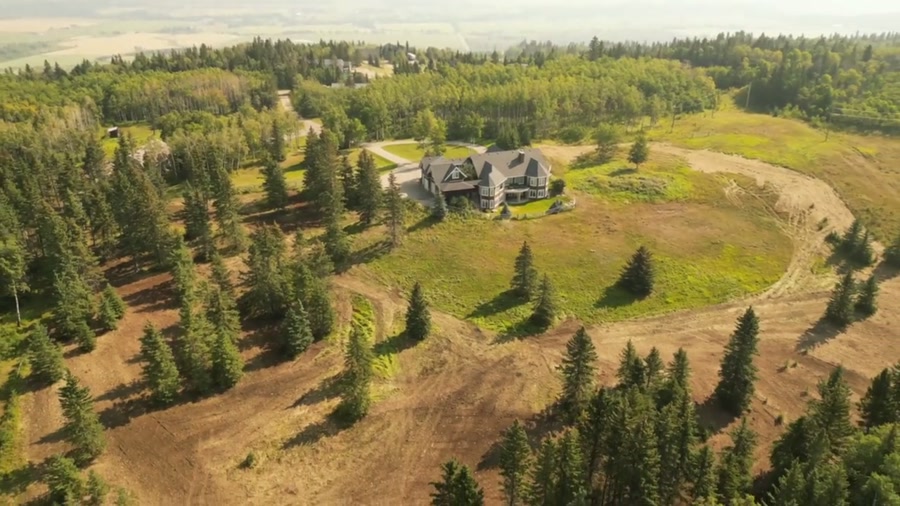
Film, photography and aerial cinematography for the homes, businesses and places that define Diamond Valley. Foothills bench country split by a wooded river valley — the two former townsites face each other across it, and the ranch land climbs west from the last streets toward the front ranges.
Does Atom2Adam work in Diamond Valley?
Yes. Atom2Adam makes film, photography and aerial cinematography in Diamond Valley, Alberta — for homes, businesses and brands. For aerial work the airspace is Class G uncontrolled. No airspace authorisation is normally required. From the Calgary studio, mobilisation is typically 40 minutes.
Diamond Valley at a glance
| Studio | Calgary, Alberta |
|---|---|
| Drive from the studio | 40 minutes |
| Airspace | Class G uncontrolled |
| Nearest aerodrome | Okotoks Air Park |
| Aerial authorisation | Not normally required |
| Aerial status | Standard RPAS rules apply |
| Certification | Transport Canada RPAS — Advanced Operations |
| Response | We reply within one business day |
| Airspace record derived | 2026-09-01 |
Working in Diamond Valley.
The treed river corridor between Diamond Valley's two halves runs its own calendar — leafed out before the benches in spring, gold ahead of them in autumn, and holding snow in its shade after Government Rd and Centre Ave are bare. The same address can read lush, golden or flat depending on the week, so a shoot booked to a diary date instead of the corridor's stage often misses the setting the town actually sells on.
Shoots here are timed to the valley's stage, and when the colour window opens, a golden-hour hold over the corridor catches it — delivered on the turnaround agreed at booking.
Light. The valley corridor carries the seasonal story — first green in spring, a short gold window in autumn, snow lingering in its shade — while evening light rakes the benches from the west.
Terrain. Foothills bench country split by a wooded river valley — the two former townsites face each other across it, and the ranch land climbs west from the last streets toward the front ranges.
Wind. Chinook belt, hard against the foothills. West wind comes off the front ranges with the gust spread already built in, and the open bench ground takes it at full strength.
Airspace. Diamond Valley lies outside the charted Calgary-area control zones in uncontrolled Class G airspace, about 22 km from Okotoks Air Park. No airspace authorisation is normally required. The specific site and altitude are confirmed against NAV Drone before every flight.
On the ground. Town of Diamond Valley park and pathway rules govern launch and landing on municipal land; private-property launch with the owner's permission is the default. About 40 minutes southwest of the Calgary base. A straightforward same-day booking, often paired with Millarville or Longview work on the same trip.
What we make for Diamond Valley.
Every subject is approached the same way — creative direction, film, photography, aerial and post-production, scoped and quoted before anything is booked.
Diamond Valley and what surrounds it.
- Film and photography in Okotoks19 km · Class G uncontrolled
- Film and photography in High River29 km · Class G uncontrolled
- Film and photography in Longview22 km · Class G uncontrolled
- Film and photography in Priddis21 km · Class G uncontrolled
- Film and photography in Aldersyde23 km · Class G uncontrolled, local aerodrome nearby
How a Diamond Valley shoot runs.
- 01Brief and scope. Diamond Valley lends itself to luxury homes and acreages and estates; the shot list follows the subject. Mobilisation is stated separately from the fee.
- 02Airspace, where the brief includes aerial work. Checked against NAV Drone from the address, not the postcode. Diamond Valley is class g uncontrolled, so authorisation is not normally required — but Okotoks Air Park is 22 km away and its circuit is plotted regardless.
- 03Light and weather. Chinook belt, hard against the foothills. West wind comes off the front ranges with the gust spread already built in, and the open bench ground takes it at full strength. The valley corridor carries the seasonal story — first green in spring, a short gold window in autumn, snow lingering in its shade — while evening light rakes the benches from the west.
- 04Shoot day. About 40 minutes from the Calgary studio. Launch from the subject property with the owner's permission; town of Diamond Valley park and pathway rules govern launch and landing on municipal land; private-property launch with the owner's permission is the default.
- 05Post-production and delivery. Edited, graded and finished for every format it will live in, delivered digitally — which is how owners of Diamond Valley property who live elsewhere can be served.
Diamond Valley questions, answered.
Is drone flight over Diamond Valley restricted?
No. Diamond Valley sits in uncontrolled Class G airspace, about 22 km from Okotoks Air Park and outside the charted Calgary-area control zones, so no airspace authorisation is normally required. The specific site and altitude are confirmed against NAV Drone before every flight, the same check that runs on every booking.
When is the best time of year to photograph a Diamond Valley property?
Match the booking to the river corridor rather than the calendar. The treed valley between the town's two halves greens up ahead of the benches in spring and turns gold for a short window in autumn — the strongest colour the town shows. Shooting to that stage decides how much of the setting a listing keeps.
Can the Turner Valley Gas Plant National Historic Site appear in aerial work?
As context, yes. The site reads clearly from a lawful orbit flown off adjacent property, so it can anchor a frame without being overflown. Launches stage from private property with the owner's consent, and any work over the site itself is arranged with its operators rather than assumed.
Diamond Valley is 19 km from Okotoks.
Every quote starts at the Calgary studio, which is why identical subjects in Diamond Valley and Okotoks — 19 km apart — price differently.
Nearby
Airspace record derived from the published airspace geometry on . Rules change — the exact site is confirmed against NAV Drone before every flight.