Nanton, Alberta
Creative production in Nanton.
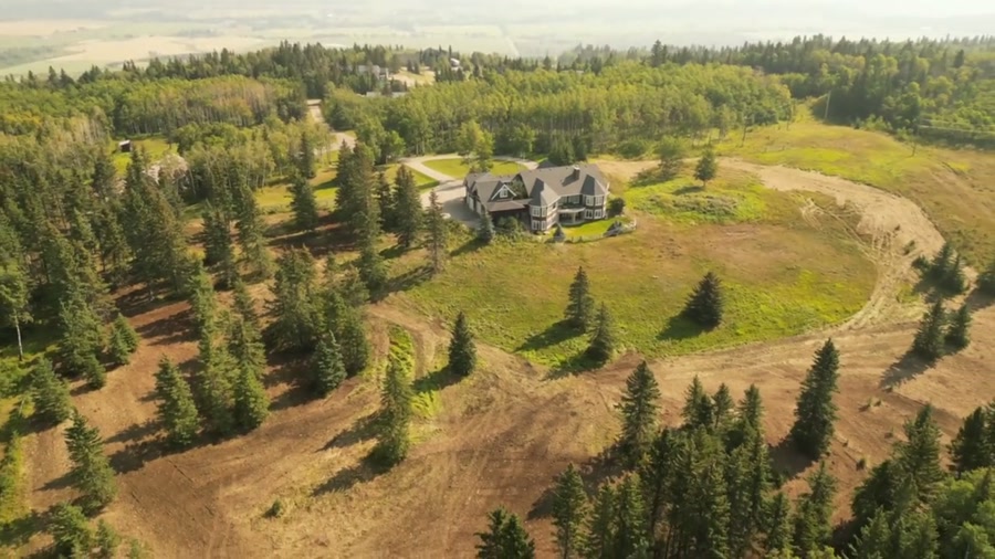
Film, photography and aerial cinematography for the homes, businesses and places that define Nanton. Flat, open grain land on the survey grid running east from town, with the first ridge of the foothills rising close on the western side — prairie and hill country meeting at the townsite.
Does Atom2Adam work in Nanton?
Yes. Atom2Adam makes film, photography and aerial cinematography in Nanton, Alberta — for homes, businesses and brands. For aerial work the airspace is Class G uncontrolled. No airspace authorisation is normally required. From the Calgary studio, mobilisation is typically 1.2 hours.
Nanton at a glance
| Studio | Calgary, Alberta |
|---|---|
| Drive from the studio | 1.2 hours |
| Airspace | Class G uncontrolled |
| Nearest aerodrome | High River aerodrome |
| Aerial authorisation | Not normally required |
| Aerial status | Standard RPAS rules apply |
| Certification | Transport Canada RPAS — Advanced Operations |
| Response | We reply within one business day |
| Airspace record derived | 2026-09-01 |
Working in Nanton.
West wind reaches Nanton off the high country around Chain Lakes Reservoir and crosses the Hwy 2 corridor with almost nothing left to slow it — of the whole southern run, this is the ground where the wind meter matters most. A shoot booked here like a calendar appointment stands a real chance of being scrubbed on arrival, because the gust spread that grounds a small airframe can build in the space of an afternoon.
Nanton work is booked into a forecast wind window — usually the morning end of the day — with the date held flexible around it, and the finished set still lands on the turnaround agreed at booking.
Light. Mornings are the working end of the day here — light and wind are both usually kinder before noon — and the surrounding grain quarters carry their best colour in the weeks around harvest.
Terrain. Flat, open grain land on the survey grid running east from town, with the first ridge of the foothills rising close on the western side — prairie and hill country meeting at the townsite.
Wind. The strongest, most persistent wind in the southern service area. West and southwest flow is the default condition; a calm day is the exception the schedule is built to catch.
Airspace. Nanton lies outside the charted Calgary-area control zones in uncontrolled Class G airspace, about 20 km from High River aerodrome. No airspace authorisation is normally required. Before any flight, the exact site and altitude are checked against NAV Drone.
On the ground. Town of Nanton park and pathway rules govern municipal land — Nanton Lagoon Park is not treated as a launch site — and takeoff from private property with consent is the default. About 70 minutes south of the Calgary base on Hwy 2. Booked as a half-day window so the shoot can move inside it with the wind; High River and Cayley sit on the same run.
What we make for Nanton.
Every subject is approached the same way — creative direction, film, photography, aerial and post-production, scoped and quoted before anything is booked.
Nanton and what surrounds it.
- Film and photography in Longview33 km · Class G uncontrolled
- Film and photography in Diamond Valley50 km · Class G uncontrolled
- Film and photography in High River26 km · Class G uncontrolled
- Film and photography in Okotoks43 km · Class G uncontrolled
- Film and photography in Aldersyde39 km · Class G uncontrolled, local aerodrome nearby
How a Nanton shoot runs.
- 01Brief and scope. Nanton lends itself to farms and ranch land and acreages and estates; the shot list follows the subject. Mobilisation is stated separately from the fee.
- 02Airspace, where the brief includes aerial work. Checked against NAV Drone from the address, not the postcode. Nanton is class g uncontrolled, so authorisation is not normally required — but High River aerodrome is 20 km away and its circuit is plotted regardless.
- 03Light and weather. The strongest, most persistent wind in the southern service area. West and southwest flow is the default condition; a calm day is the exception the schedule is built to catch. Mornings are the working end of the day here — light and wind are both usually kinder before noon — and the surrounding grain quarters carry their best colour in the weeks around harvest.
- 04Shoot day. About 70 minutes from the Calgary studio. Launch from the subject property with the owner's permission; town of Nanton park and pathway rules govern municipal land — Nanton Lagoon Park is not treated as a launch site — and takeoff from private property with consent is the default.
- 05Post-production and delivery. Edited, graded and finished for every format it will live in, delivered digitally — which is how owners of Nanton property who live elsewhere can be served.
Nanton questions, answered.
Does flying a drone in Nanton require authorisation?
Normally, no. Nanton sits in uncontrolled Class G airspace, about 20 km from High River aerodrome and outside the charted Calgary-area control zones, so routine flights need no airspace authorisation. The specific site and altitude are confirmed against NAV Drone before every flight, as they are everywhere we fly.
Is Nanton's wind a problem for drone shoots?
Yes, and it is planned for. West wind comes down from the high country around Chain Lakes Reservoir and crosses town at full strength, so a Nanton shoot is booked against a forecast wind window — mornings are usually the calmer end — rather than a fixed hour on a calendar.
Can the Bomber Command Museum of Canada be shown in aerial frames?
As townsite context, yes. The museum sits beside Hwy 2 and reads clearly from a lawful orbit flown off neighbouring property, so it can locate a commercial or residential frame at a glance. Launches stage from private property with consent, and any work over the museum itself is arranged with the museum first.
Nanton is 33 km from Longview.
Mobilisation is quoted from the Calgary studio, so a shoot in Nanton and one 33 km away in Longview are priced differently even when the subject is identical.
Nearby
Airspace record derived from the published airspace geometry on . Rules change — the exact site is confirmed against NAV Drone before every flight.