Millarville, Alberta
Creative production in Millarville.
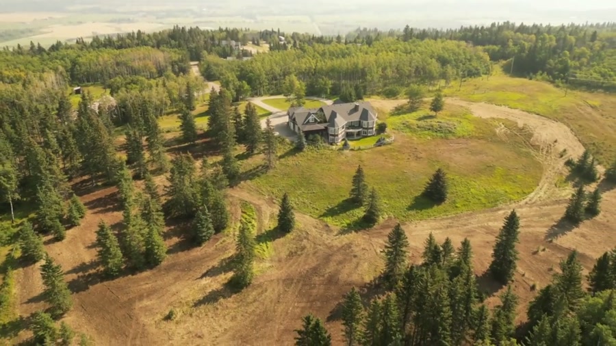
Film, photography and aerial cinematography for the homes, businesses and places that define Millarville. Rolling, partly treed foothill country — aspen stands and open pasture folded together, with acreages strung along the roads rather than gathered into a townsite.
Does Atom2Adam work in Millarville?
Yes. Atom2Adam makes film, photography and aerial cinematography in Millarville, Alberta — for homes, businesses and brands. For aerial work the airspace is Class G uncontrolled. This airspace does not normally require an authorisation. Typical mobilisation from the Calgary studio is 40 minutes.
Millarville at a glance
| Studio | Calgary, Alberta |
|---|---|
| Drive from the studio | 40 minutes |
| Airspace | Class G uncontrolled |
| Nearest aerodrome | Okotoks Air Park |
| Aerial authorisation | Not normally required |
| Aerial status | Standard RPAS rules apply |
| Certification | Transport Canada RPAS — Advanced Operations |
| Response | We reply within one business day |
| Airspace record derived | 2026-09-01 |
Working in Millarville.
Millarville barely exists as a townsite from the air — what reads instead is a crossroads district, acreages strung along Millarville Rd and Hwy 22, with the oval of the Millarville Racetrack as the largest built shape in the district. With no streetscape anywhere, a ground photograph strands a property in anonymous foothill country — nothing in frame says where it is, how it is reached, or what kind of district surrounds it.
An approach run flown along the property's own road into a boundary-line orbit keeps one named line — Millarville Rd, Hwy 22 or the racetrack itself — in frame as a locator, delivered on the turnaround agreed at booking.
Light. The aspen stands set the calendar — a short, strong gold window in autumn and the freshest green in the district in spring — and snow holds in the treed folds after the open pasture has cleared.
Terrain. Rolling, partly treed foothill country — aspen stands and open pasture folded together, with acreages strung along the roads rather than gathered into a townsite.
Wind. Chinook belt in the first folds of the foothills. The treed rolls take some of the edge off surface gusts; above the canopy the west wind runs unbroken.
Airspace. In uncontrolled Class G airspace about 27 km from Okotoks Air Park, Millarville lies outside the charted Calgary-area control zones, and no authorisation is normally required. Every flight is preceded by a NAV Drone check of the specific site and altitude.
On the ground. Public-land launches in the district fall under Foothills County rules; staging from the client's own property, with consent, is the standard practice. About 40 minutes from the Calgary base. An easy same-day booking, with Priddis or Diamond Valley close enough to share the mobilisation.
What we make for Millarville.
Every subject is approached the same way — creative direction, film, photography, aerial and post-production, scoped and quoted before anything is booked.
Millarville and what surrounds it.
- Film and photography in Priddis16 km · Class G uncontrolled
- Film and photography in Okotoks24 km · Class G uncontrolled
- Film and photography in Diamond Valley7 km · Class G uncontrolled
- Film and photography in De Winton28 km · Class G uncontrolled
- Film and photography in High River35 km · Class G uncontrolled
How a Millarville shoot runs.
- 01Brief and scope. Millarville lends itself to acreages and estates and luxury homes; the shot list follows the subject. Mobilisation is stated separately from the fee.
- 02Airspace, where the brief includes aerial work. Checked against NAV Drone from the address, not the postcode. Millarville is class g uncontrolled, so authorisation is not normally required — but Okotoks Air Park is 27 km away and its circuit is plotted regardless.
- 03Light and weather. Chinook belt in the first folds of the foothills. The treed rolls take some of the edge off surface gusts; above the canopy the west wind runs unbroken. The aspen stands set the calendar — a short, strong gold window in autumn and the freshest green in the district in spring — and snow holds in the treed folds after the open pasture has cleared.
- 04Shoot day. About 40 minutes from the Calgary studio. Launch from the subject property with the owner's permission; public-land launches in the district fall under Foothills County rules; staging from the client's own property, with consent, is the standard practice.
- 05Post-production and delivery. Edited, graded and finished for every format it will live in, delivered digitally — which is how owners of Millarville property who live elsewhere can be served.
Millarville questions, answered.
Are there airspace restrictions over Millarville?
None beyond the standard rules. Millarville lies in uncontrolled Class G airspace, about 27 km from Okotoks Air Park and outside the charted Calgary-area control zones, so no airspace authorisation is normally required. The exact site and altitude are still confirmed against NAV Drone before every flight.
How do you photograph a Millarville acreage when there is no town to frame it?
With the roads. Millarville is a district rather than a townsite, so a property here is located from the air by its relationship to Millarville Rd, Hwy 22 and the county grid. The orbit is planned to keep one of those lines in frame while the buildings stay large enough to read.
Can the Millarville Racetrack appear in an aerial shoot?
For nearby properties, often yes. The racetrack oval is the largest built shape in the district and a genuine locator — a frame that holds it places an acreage instantly. It stays in frame as context from a lawful distance; work over the grounds themselves is arranged with the operators, not assumed.
Millarville is 16 km from Priddis.
Because mobilisation is quoted from the Calgary studio, Millarville and Priddis, 16 km away, carry different quotes for an identical subject.
Nearby
Airspace record derived from the published airspace geometry on . Rules change — the exact site is confirmed against NAV Drone before every flight.