Red Deer, Alberta
Film and aerial production in Red Deer.
Atom2Adam, a global creative consultancy and media agency operating from Calgary, is available for commissions in Red Deer: brand films for its manufacturers and oilfield-services firms, photography for its downtown and its venues, and aerial cinematography planned around the airport zone that crosses the south end.
From the work

No published project is placed in Red Deer; this film and the frames below are shown for the subjects its commissions ask for — equipment on the move, a river through a downtown, a storefront.
Does Atom2Adam work in Red Deer?
Yes. Atom2Adam, a consultancy and media agency working worldwide from its Calgary base, makes film, photography and aerial cinematography in Red Deer, Alberta — for homes, businesses and brands. For aerial work the airspace is Class D control zone (CYQF) over the south end; Class G downtown. Aerial work here flies under an Advanced RPAS certificate, and the airspace authorisation is filed before any shoot date is confirmed. From the Calgary base, mobilisation is typically 1.8 hours.
A city that builds for the oil patch and gathers Central Alberta.
Red Deer is Central Alberta's working city. The City of Red Deer reports 62,224 jobs across more than 4,000 businesses, led by health care, retail, construction, oil and gas, hospitality and manufacturing, and says virtually every component used in the oil and gas industry is manufactured here — metal fabrication, petrochemicals and drilling equipment, shipped to customers all over the world. For Atom2Adam that means brand films about how things are made: the shop floor, the yard and the load leaving on the QEII.
Westerner Park, on Red Deer's south end, draws more than 1.5 million visitors a year and hosts Agri-Trade, which its organisers say brings over 32,000 agricultural buyers and more than 500 equipment manufacturers and service providers to the city every November. Westerner Days returns July 21–25, 2027, with chuckwagon racing, a parade and a midway — an events calendar fixed far enough ahead to plan films and exhibitor content around it.
The Red Deer River gives the city its frame. More than 110 km of Waskasoo Park trail follow the valley, the Capstone district and Canada 150 Square front the river, and the City's Capstone master plan imagines 5,000 new residents and 2 million square feet of commercial space — riverfront growth that a property film or a repeat-visit aerial series can record as it rises.
The work, in the order Red Deer needs it.
- 01
Film
Brand films for Red Deer's manufacturers and oilfield-services firms — the plant, the yard and the equipment on the road — cut for the customers they ship to worldwide.
- 02
Consultancy & Creative Direction
Shot lists written around the airport zone edge, the parks bylaw's overnight hours and the Westerner Park calendar, so a Red Deer day is spent filming rather than waiting on permission.
- 03
Photography
Photography for Historic Downtown's shops and cafés, the hotels along the QEII and venues such as Heritage Ranch and the Kerry Wood Nature Centre.
- 04
Aerial
Aerial cinematography of the river valley and the industrial parks under an Advanced RPAS certificate, with a NAV CANADA authorisation requested through NAV Drone wherever a site falls inside the CYQF zone.
- 05
Post-Production
Editing, colour and sound finished for trade-show screens, sales decks and social cuts, delivered digitally to head offices wherever they are.
Red Deer at a glance
| Agency | Global creative consultancy & media agency |
|---|---|
| Operating base | Calgary, Alberta, Canada |
| Drive from the base | 1.8 hours |
| Airspace | Class D control zone (CYQF) over the south end; Class G downtown |
| Nearest aerodrome | Red Deer Regional Airport (CYQF) |
| Aerial authorisation | Yes — filed before the date is confirmed |
| Aerial status | Flown under airspace authorisation |
| Certification | Transport Canada RPAS — Advanced Operations |
| Response | We reply within one business day |
| Airspace record derived | 2026-10-05 |
Working in Red Deer.
Red Deer's events grounds and its downtown are filmed under different rules. Westerner Park, Red Deer Polytechnic and Gasoline Alley sit inside the airport's control zone on the published geometry, while the river-valley core sits about 2.2 km outside it. A shot list that treats the city as one place books a Westerner Park or Gasoline Alley aerial as if it were downtown, and loses the date to an authorisation nobody requested.
Every address is plotted against the charted zone edge at scoping: sites inside it go to NAV CANADA through NAV Drone before a date is confirmed, and downtown flights are planned to the hospital heliport procedure.
Light. September is the clearest month on Environment and Climate Change Canada's 1991–2020 normals (211.9 hours with 0–2 tenths cloud), with an equinox sunset near 19:33, while June is the wettest month (97.7 mm) and the cloudiest of the summer. Fog forms overnight in spring and fall and often holds until mid-morning, on about 23 days a year. A 21 June day runs from 05:14 to 22:01, while 21 December holds only about 7 h 41 min of daylight, so winter exteriors are paired with interiors.
Terrain. The Red Deer River valley holds the city in a bowl: NAV CANADA's weather manual describes Red Deer as sitting in a bowl-like depression within the valley. The river flats downtown lie near 860 m and the upland rises about 75–80 m within 7–8 km east and west, while the south end around Westerner Park sits about 30 m above the core. More than 110 km of Waskasoo Park trail follow the valley through the city.
Wind. Wind follows the valley: NAV CANADA's weather manual says it is generally from the northwest or south all year, and Environment and Climate Change Canada's 1991–2020 normals put the mean at 11.0 km/h, windiest in April and May (13.2–13.6 km/h) and calmest in August (9.4 km/h). Chinooks are common in the Red Deer–Calgary region, and thunderstorm cells that form over the foothills in the morning frequently move through Red Deer later in the day.
Airspace. Downtown Red Deer sits about 2.2 km outside the 5 NM (9.3 km) Class D control zone around Red Deer Regional Airport (CYQF), as charted in NAV CANADA's Designated Airspace Handbook, but the zone's edge crosses the south end: on the published geometry Westerner Park, Red Deer Polytechnic, Bower Place and Gasoline Alley sit inside it, and a flight there needs an RPAS Flight Authorization from NAV CANADA, requested through NAV Drone, before a date is confirmed. Downtown is also about 0.8 km from the Red Deer Regional Hospital Centre heliport, which makes every downtown flight an Advanced operation flown to the heliport procedure. The specific site is confirmed against NAV Drone before every flight.
On the ground. The City of Red Deer requires no drone permit and defers to Transport Canada, but Parks and Public Facilities Bylaw 3255/2000 closes City parks to gatherings of five or more people from 11 p.m. to 7 a.m. without the City Manager's written authorization, and a road closure, stage or amplified sound makes a shoot a Special Event under Bylaw 3572/2016. The working default is to launch from the client's own property with consent. About 110 minutes and 148 km north of the Calgary base on Deerfoot Trail and the QEII, so a full shoot day is a day trip in summer, when daylight runs past 22:00. Winter days and sunrise starts are booked with an overnight, and Sylvan Lake, about 20 km west, can share the same trip.
What gets commissioned in Red Deer.
Manufacturing brand film
A film for a fabricator or drilling-equipment maker in Queens Business Park or Gasoline Alley: the shop floor, the yard and a finished load heading out on the QEII.
Agri-Trade exhibitor films
Short films and stills for exhibitors at Agri-Trade each November, made indoors at Westerner Park, where the venue's permission governs rather than Transport Canada's drone rules.
Capstone riverfront series
A repeat-visit aerial and photography series that follows the Capstone district's build-out beside the Red Deer River, frame for frame.
Venues and weddings
Photography and film for venues that rent for weddings and business events — Heritage Ranch, Historic Fort Normandeau and the Kerry Wood Nature Centre.
Frames from the work
None of these frames comes from a project placed in Red Deer; each caption says where its frame was made.
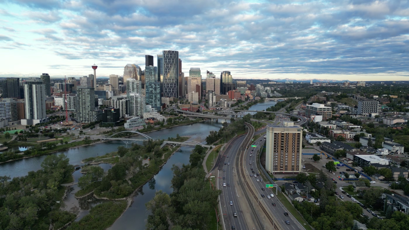
A downtown from above its river: bridges, a light-rail line along the bank and towers against the mountains. Made in Calgary, Alberta.Downtown Calgary 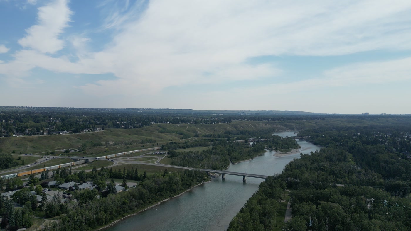
A river running under a road bridge, a freight train on the far bank and truss rail bridges downstream. Made in Bowness, Calgary, Alberta.Bowness 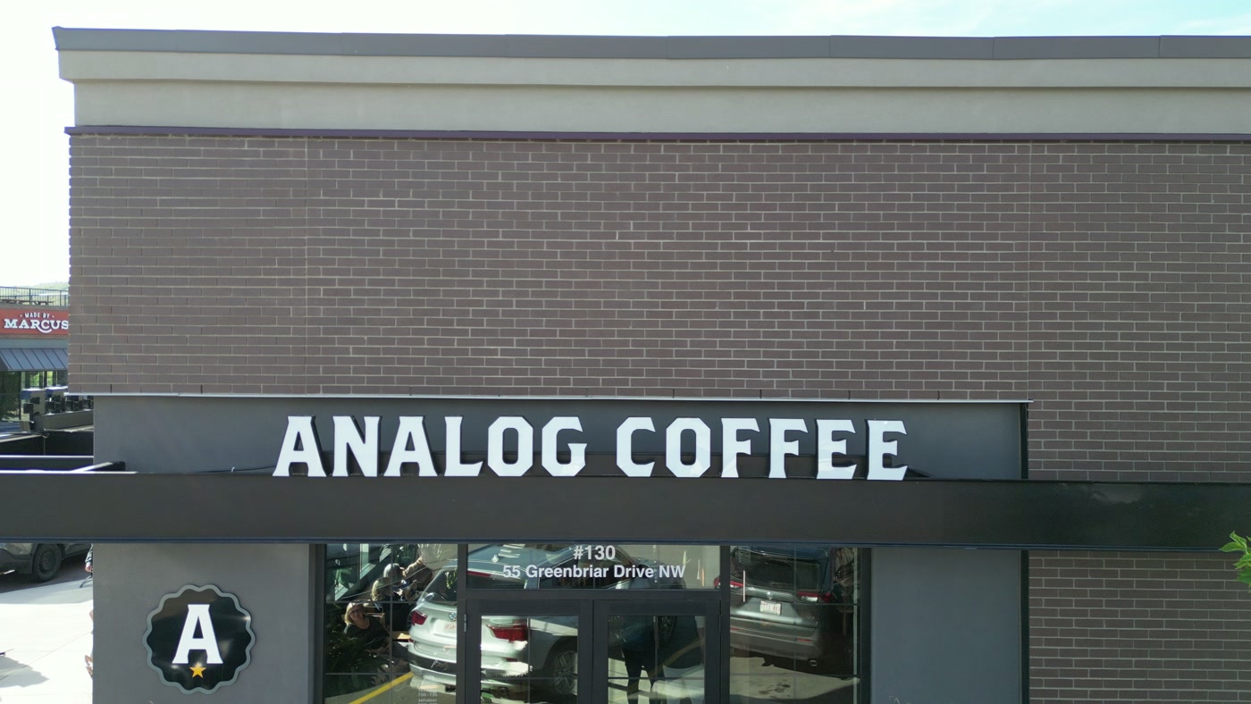
A café fascia in white capitals over glass doors, a roundel logo beside it. Made in Calgary, Alberta.Analog Coffee


What we make for Red Deer.
- Brand and campaign films
- Hospitality and tourism
- Cafés, restaurants and shops
- Places and landmarks
- Property aerials
Every subject is approached the same way — creative direction, film, photography, aerial and post-production, scoped and quoted before anything is booked.
Red Deer and what surrounds it.
- Film and photography in Sylvan Lake20 km · Class G uncontrolled, well clear of the nearest control zone
- Film and photography in Olds57 km · Class G uncontrolled
- Film and photography in Didsbury72 km · Class G uncontrolled
- Film and photography in Sundre77 km · Class G uncontrolled, local aerodrome nearby
- Film and photography in Carstairs81 km · Class G uncontrolled
Named in Red Deer
Waskasoo ParkBower PondsGaetz Lakes SanctuaryKerry Wood Nature CentreWesterner ParkCapstoneCanada 150 SquareRoss Street PatioHeritage RanchSt. Mary's Church
How a Red Deer shoot runs.
- 01Brief and scope. Red Deer lends itself to brand and campaign films and hospitality and tourism; the shot list follows the subject. Mobilisation is stated separately from the fee.
- 02Airspace, where the brief includes aerial work. Red Deer sits under Red Deer Regional Airport (CYQF), 11.5 km away. Authorisation is filed with NAV CANADA and the date is confirmed once it is in hand.
- 03Light and weather. Wind follows the valley: NAV CANADA's weather manual says it is generally from the northwest or south all year, and Environment and Climate Change Canada's 1991–2020 normals put the mean at 11.0 km/h, windiest in April and May (13.2–13.6 km/h) and calmest in August (9.4 km/h). Chinooks are common in the Red Deer–Calgary region, and thunderstorm cells that form over the foothills in the morning frequently move through Red Deer later in the day. September is the clearest month on Environment and Climate Change Canada's 1991–2020 normals (211.9 hours with 0–2 tenths cloud), with an equinox sunset near 19:33, while June is the wettest month (97.7 mm) and the cloudiest of the summer. Fog forms overnight in spring and fall and often holds until mid-morning, on about 23 days a year. A 21 June day runs from 05:14 to 22:01, while 21 December holds only about 7 h 41 min of daylight, so winter exteriors are paired with interiors.
- 04Shoot day. About 1.8 hours from the Calgary base. Launch from the subject property with the owner's permission; the City of Red Deer requires no drone permit and defers to Transport Canada, but Parks and Public Facilities Bylaw 3255/2000 closes City parks to gatherings of five or more people from 11 p.m. to 7 a.m. without the City Manager's written authorization, and a road closure, stage or amplified sound makes a shoot a Special Event under Bylaw 3572/2016. The working default is to launch from the client's own property with consent.
- 05Post-production and delivery. Edited, graded and finished for every format and market it will live in, delivered digitally — which is how owners of Red Deer property who live elsewhere, anywhere in the world, are served by a global agency.
Red Deer questions, answered.
Is downtown Red Deer inside the airport's controlled airspace?
No, not on the published geometry. Downtown sits about 2.2 km outside the 5 NM Class D control zone around Red Deer Regional Airport (CYQF), but the zone's edge crosses the south end, so Westerner Park, Red Deer Polytechnic, Bower Place and Gasoline Alley sit inside it and need a NAV CANADA authorisation requested through NAV Drone. Downtown is also about 0.8 km from the hospital heliport, so every flight there is an Advanced operation, and each site is confirmed in NAV Drone before it is flown.
Can a drone film Westerner Days or an event at Westerner Park?
Only with two permissions. Westerner Park sits inside the airport's Class D control zone on the published geometry, so it needs a NAV CANADA authorisation through NAV Drone, and Transport Canada bars every drone, microdrones included, from flying near or at an advertised outdoor event without a Special Flight Operations Certificate (SFOC), filed at least 30 working days ahead. Westerner Days next runs July 21–25, 2027. Indoor work at the Marchant Crane Centrium or the Exhibition Hall falls outside Transport Canada's drone rules and needs only the venue's permission.
Can a crew film a summer sunrise in a Red Deer city park?
Yes, with the City Manager's written authorization. Red Deer's Parks and Public Facilities Bylaw 3255/2000 closes City parks to gatherings of five or more people from 11 p.m. to 7 a.m., and the 21 June sunrise is at 05:14, so a full crew at Bower Ponds or on a Waskasoo Park trail at first light asks the City first. The same bylaw needs the City Manager's written permission to offer a paid service in a park, so a commercial shoot raises that in the same request.
Our company is based outside Alberta — can you film our Red Deer plant or hotel without us travelling?
Yes. Production travels from the Calgary base, about 148 km and 110 minutes by road, while the creative direction, the shot list and the post-production review all happen remotely with your team. The client covers travel at cost, and the finished films and photographs are delivered digitally to wherever the company is based. The City notes that Red Deer's oilfield-services firms sell and ship their products to customers all over the world — usually the audience a plant film is made for.
What does a brand film for a Red Deer manufacturer involve?
Planning the plant and its airspace together. The City says virtually every component used in the oil and gas industry is manufactured in Red Deer, and the industrial parks split by airspace: Queens Business Park sits outside the airport's control zone, while Gasoline Alley's Energy and Petrolia parks sit inside it, so aerials there need NAV CANADA authorisation first. Gasoline Alley lies in Red Deer County, outside the City's bylaws, so permissions there are confirmed with the County and the landowner.
Red Deer is 20 km from Sylvan Lake.
Mobilisation is quoted from the Calgary base, so a shoot in Red Deer and one 20 km away in Sylvan Lake are priced differently even when the subject is identical.
Nearby
Airspace record derived from the published airspace geometry on . Rules change — the exact site is confirmed against NAV Drone before every flight.